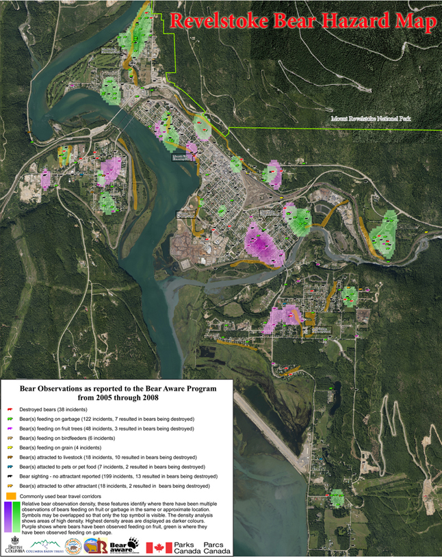

Earlier this year a bear hazard map was created for the City of Revelstoke and surrounding area. The map was created using information collected from the Provincial Problem Wildlife phone line, information from our local Conservation Officer Adam Christie and valuable and much appreciated support of Parks Canada GIS specialist Ron Larsen.
The bear hazard map is one of the criteria required for completing the Ministry of the Environment provincial initiative to become a Bear Smart community.
The sites plotted on the map are from information collected between 2005 and 2008. Locations where action taken was to destroy the bear are marked using a red bear. Sightings where an attractant was present are labeled using different colored bears, the number of incidents involving each attractant is noted on the map’s legend as well as the number of incidents that resulted in a bear being destroyed.
In cases where there have been more than one incident reported at the same location only one bear symbol will show on the map, according to the order identified on the legend. For example if there was a bear feeding on garbage and birdfeeders at the same location, the green garbage bear symbol would appear on the map.
A density analysis was done for garbage and fruit sighting. The relative bear observation density is shown in green for garbage and purple for fruit. This analysis identifies areas where there have been multiple observations of bears feeding on fruit or garbage in the same or approximate location. The areas of highest density are displayed as darker colours.
From the map we see that bears have been sighted throughout the community. Areas of highest concern are those which are adjacent to active wildlife interfaces and near commonly used bear travel corridors. Active wildlife interfaces occur in the neighbourhoods adjacent to Mount Revelstoke National Park, the Colombia River, the Illecillewaet River and Mount Mackenzie.
Mapping the location where bears feed on garbage and fruit allows for a better understanding of the problem areas in the community, and highlights where changes are needed and where to target education from the Bear Aware program. The Bear Hazard Map will be updated each year, allowing for a visual image of changes in availability of different attractants to bears over time.
A large 3 x 3.5 foot version of the bear hazard map will be display at the Farmer’s Market this weekend (Sept 12). As well the RAPP (Report all Poachers and Polluters) van and Conservation Officer Service will be at the market to provide information and answer questions. Revelstoke Bear Aware will be set up with a Bear Aware survey including prizes kindly donated by Canadian Mountain Holidays. Come down to the market to have a look!
For more information on Revelstoke Bear Aware visit revelstokebearaware.org or call 250-837-8624. For information regarding the provincial Bear Smart initiative visit http://www.env.gov.bc.ca/wld/bearsmart/bearsmintro.html.
To see a large-scale version of the map in PDF format please go to https://legacy.revelstokecurrent.com//wp-content/uploads/2009/09/online-bear-hazard-map1.pdf.
Penny Page-Brittin is Revelstoke’s Bear Aware Coordinator


