Those that live in Revelstoke that head out to the lower mainland for family visits, hockey tournaments or use the highways daily as their source of income, know where all the rest stops are.
For many in this area, a stop in Kamloops is sufficient for a destination goal of Surrey or Vancouver. However, as young couples expand on the family name, numerous stops along the highways are almost always a certainty with toddlers in tow.
One are that has been a mainstay on the Coquihalla Highway was the tourist centre/rest stop located near Merritt at the Highway 5 and Highway 97C that was just recently closed indefinitely.
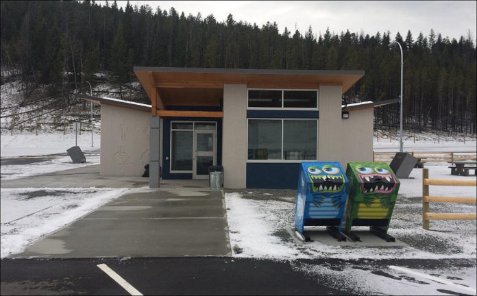
The new rest area is at the Loon Lake interchange that is between Merritt and Kelowna- not a huge distance from the long standing visitors centre. There are eight new pit stops throughout BC and all of them will have free Wi-Fi. This new rest area is roughly 40 kilometres southeast of Merritt and is a top notch facility with running water and flushing toilets and a up to date design. In terms of parking, it has separate parking locations for commercial, motorhomes and passenger vehicles to make it easier for movement. There is a goal to install electric car stalls in the spring of 2018.
Minister of Transportation and Infrastructure Claire Trevena stated in a release, “It is important for travellers to stay fresh and alert on long trips, and Loon Lake’s new rest area provides an option on the Okanagan Connector. Commercial truck drivers and travellers alike have told us they want more highway rest areas and improvements to the existing stops, and this one has amenities for all to benefit from when they need a break from the road.”
Almost $10 million dollars has been invested in rest-area enhancements throughout B.C. since 2015 which is how this new Loon Lake rest are with free Wi-Fi is attainable.
If you are travelling out of Revelstoke this spring/summer and would like to know where the new stops are for free Wi-Fi, here is the list of upgraded facilities.
- Hunter Creek on Highway 1 – 11 kilometres west of Hope
- Bradner on Highway 1 – 53 kilometres east of Vancouver
- Cole Road on Highway 1 – 73 kilometres east of Vancouver
- The Last Spike on Highway 1 – 24 kilometres east of Sicamous
- Slim Creek on Highway 16 – 120 kilometres east of Prince George
- Mount Terry Fox on Highway 16 – six kilometres east of Tête Jaune
- Boulder Creek on Highway 16 – 53 kilometres west of Hazelton


