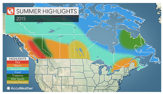
At least one weather service is predicting a very warm summer with an excellent chance of an active forest fire season.
AccuWeather.com is forecasting that dry conditions will persist into the summer across the valleys of south-central British Columbia and this will lead to an increase in spells of hot weather. Off the west coast, the surface waters of the eastern Pacific will likely remain unusually warm, causing a warming influence in cities such as Vancouver and Victoria this summer.
The prevalence of very warm to hot weather across much of western Canada this upcoming summer will enhance afternoon thunderstorm activity over the Rockies, leading to an increased risk of flash flooding in areas such as Banff National Park.
The unusually warm winter of 2014-2015 in western Canada likely resulted in the survival of a large population of the Pine Bark Beetle, AccuWeather said in its latest prediction.
The beetle has been causing tremendous damage to the western forests, making them more susceptible to devastating wildfires. With more thunderstorms predicted in the mountains, the increase in dry lightning strikes will likely result in another active wildfire season. British Columbia has certainly seen the beginning of an early fire season.
Effective at noon PDT on Friday, May 22, Category 2 and Category 3 open fires will be prohibited in the Southeast Fire Centre to help prevent human-caused wildfires and protect public safety.
Anyone conducting Category 2 or 3 fires anywhere in the Southeast Fire Centre must extinguish any such fires by noon on May 22. This prohibition will remain in place until the public is otherwise notified.
The Southeast Fire Centre covers the area extending from the US border in the south to Mica Dam in the north and from the Okanagan Highlands and Monashee Mountains in the west to the BC-Alberta border in the east. It includes the Selkirk Natural Resource District and the Rocky Mountain Natural Resource District.
There have already been about 25 fires in BC, two of them considered “fires of note” at Little Bobtail Lake and at Pelican Lake, northwest of Quesnel. The Pelican Lake fire was 165 hectares in size and is now 100% contained. Please click here to view an interactive map of the current wildfire situation. The Little Bobtail Lake fire is southwest of Prince George and has consumed 25,000 hectares of forest and forced the evacuation of 80 people from the area. It is only 30% contained. This is a human-caused fire. Please click here to read a CBC report on that development.
East of here, cities such as Edmonton and Calgary in Alberta along with Regina in Saskatchewan will also experience a higher number of days compared to normal that reach 32° Celsius or higher.
Rainfall will be less than average across the eastern Prairies, including Winnipeg, Manitoba, this summer, as the bulk of heavier rainfall and thunderstorm events will be remain to the south and west.
Warm but comfortable over much of Eastern Canada
In the East, a dry flow of air from the west and northwest will dominate this summer from eastern Ontario, including Toronto, through southern Quebec and the Montreal area then into New Brunswick.
This pattern will result in cooler, more comfortable nights with lower humidity, while the afternoons will be warm with a higher number of days reaching 30° Celsius or warmer, compared to normal.
The upcoming summer will be a cool one across a large portion of Atlantic Canada as several fronts from the far north will bring significant cooling to the region on a consistent basis.
Reduced threat for tropical storms in late summer
The risk of a landfalling tropical storm or hurricane for the Maritimes will be lower compared to normal this upcoming season as the overall activity in the Atlantic will be reduced due in part to the strengthening El Niño.