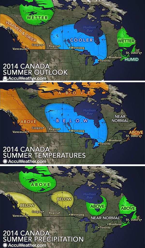
Revelstokians and other Western Canadians can expect a warmer-and-drier-than-normal summer, says the senior meteorologist for AccuWeather.com.
Brett Anderson said in a statement that above-normal temperatures and less rainfall are predicted for much of British Columbia into areas in extreme western Alberta this summer.
“The combination of increased heat and little rainfall, coupled with the ongoing Pine Bark Beetle infestation, will raise the risk for large wildfires along and west of the Continental Divide,” he said. “In Vancouver, British Columbia, the combination of high pressure and above-normal sea surface temperatures in the northeast Pacific will lead to a slightly warmer-than-normal summer with reduced chances for rainfall.”
Meanwhile, the cool weather pattern that has dominated parts of central and eastern Canada this spring will prevail into the majority of the summer, he said.
“A persistent dip in the jet stream across central and eastern Canada will lead to an increase of cool spells in the region, especially during June and July,” Anderson said. “In addition to the jet stream pattern, the record extent of ice coverage over the Great Lakes this spring has delayed the normal warming of the lakes. As a result, the lagging lake temperatures will have a cooling effect on the surrounding regions, including areas in and around Ontario, such as Thunder Bay, Sault Ste. Marie and Toronto, during the first half of the summer. The combination of below-normal temperatures and lower humidity levels will reduce the threat for severe weather this summer from the eastern Prairies into northwestern Ontario.”
While Atlantic Canada will experience a cool start to summer, the region will then experience a transition to conditions warmer and more humid than normal for the second half of the summer. For the first half of summer, near-normal rainfall is expected across most of Atlantic Canada, including Halifax, Nova Scotia, and St. John’s, Newfoundland. However, for the second half of the season, the region will shift into a period of above-normal rainfall as a more moist, southerly flow takes over with the opportunity for heavier, tropical rainfall late in the summer.