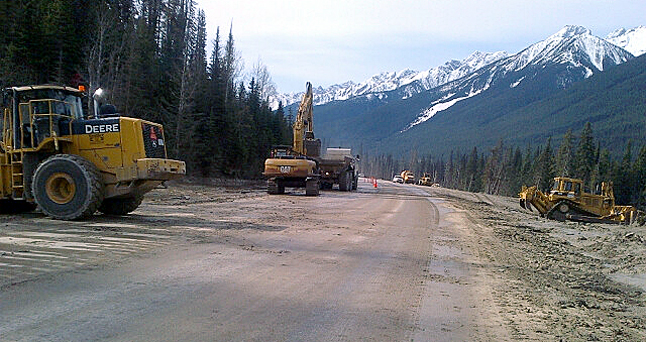
The Trans-Canada Highway was reduced to single-lane alternating traffic for part of Friday, May 16, between Revelstoke and Golden due to a landslide near the east boundary of Glacier National Park.
And while full two-way traffic was restored by 2 pm that afternoon the flow of cars and trucks along the national highway could be cut at any time this weekend.
“We could see increased instability and slippage if we receive more rain,” Parks Canada media liaison Jacolyn Daniluck said on Friday.
As a result of spring snow melt, mud, rock and tree debris are flowing down Heather Mountain and over the TCH. This is an area of previous slope instability, and in previous years catchment basins were constructed to intercept the flows. This year’s increased rate and volume of flow is greater than the basins can contain and is impacting the highway.
A statement from Parks Canada said staff and contracted workers are using heavy equipment to help stabilize the site and runoff activity is being monitored to ensure safety. Motorists should anticipate further traffic delays when travelling through this area over the next several days depending on traffic volumes, weather conditions and mud flow rates. Parks Canada asks motorists to drive cautiously as the safety of travelers and clean-up crews is a top priority.
Travellers can find updates on the Drive BC website (www.drivebc.ca) and the traveler information system (1-800-550-4997), and on the overhead highway notification signs in Revelstoke and Golden.
Relevant facts:
- The East Gate Landslide is an area of slope instability, or landslide, on the eastern boundary of Glacier National Park, above the Trans Canada Highway that has been active since January of 1997. This area commonly experiences mudslides that cover the Trans-Canada Highway during times of spring and fall run-off.
• The East Gate Landslide is 87 km east of Revelstoke and 62 km west of Golden BC. Long term and recent slope instabilities are well documented for the area.
• The East Gate Landslide affects about 1 kilometre of highway on the TCH. It is approx. 350 m wide and 1200 to 1300 metres long. The run-out stops approximately 900 m from the TCH on the above slope and sits on an average inclination of 25 at 1950 m (6500ft).
• A catchment basin was designed and built in 2001 to help stop runoff from reaching the highway. In 2009 an additional large catchment basin and large box culvert was put in place to further protect the highway. There continues to be considerable realignment of rock and dirt each year as a result of melting snowpack. This melt water, at times, carries large amounts of debris and despite mitigations can reach the TCH.
• In past years, warm weather and heavy rainfall have caused melt-water to flow through the slide area and forested buffer into the ditch on the opposite side of the highway. Weather patterns and debris flow movements are being monitored with two weather stations at the site: one at highway level and one above the top of the landslide in an effort to predict periods of probable threat of mudslides to the TCH. The present catchment basin system is working effectively and will be in place as a long-term solution for this issue.


