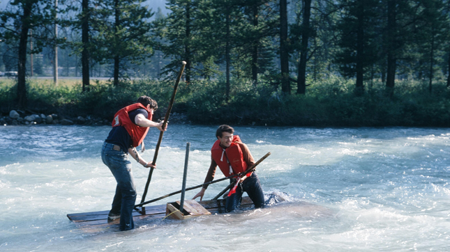

What were we thinking? Were my friends naïve, or was I as convincing as Tom Sawyer? For it was my idea, I’m sure. Mother had read Mark Twain’s Adventures of Huckleberry Finn aloud to me as a boy, and my mind images of that tale must have been triggered by subsequent sight of the muddy banks and meanders of the lower Eagle River. It’s the river that flows between The Enchanted Forest and Sicamous.
Sitting in the back seat of my parent’s car, returning to Revelstoke after some Sunday drive, I remember watching that lazy river drift to the blue waters of Shuswap Lake, and imagining how it would be to raft through the pastoral countryside around Malakwa and Solsqua. It wasn’t until July 1969 that the freedom to get that far out of town became possible when Dad bought me a used Ford Fairlane for high school graduation. Best buddy Gordon Jones immediately signed on for the adventure, of course. What possessed Warren Ennis and Ron Fujino to join our expedition, I have no idea.
After a bit of scouting, we determined to put in at the CPR siding at Taft. Here we found used timbers, probably left from some bridge maintenance, which seemed ideal for our purpose. We spent two weekends building a pair of rafts measuring about two meters by four meters. Their framework was very strong, being tied together with both wire and long spikes. Each had a wooden apple box nailed mid-ships to store a few tools and our lunches. We planned to steer using stern-mounted rudders like the rafts of old Mississippi. To this day, I have no idea how far we thought we’d get (Malakwa is 25 km distant), or even how we intended to return. Curious, Gord’s dad, Sinclair Jones, came out to Taft on the sunny Saturday chosen for the official launch.
Our rafts were rather heavy and difficult to drag off the gravel bar where we had built them, but we managed after a bit of effort. Seeing us proud and afloat, two to a raft, Sinc then drove ahead to a CPR bridge where he expected to photograph us passing beneath. He waited there some time, but we never appeared, so he went home. I hope it says something about the man’s confidence in our competency that he never sent out a search party!
That initial rush of success, anticipation, and excitement didn’t last longer than rounding the very first bend of the river, where a log lay across the stream, just above the surface. “Easy,” I thought. “Just step up on the log and then back down as the raft passes beneath.” There was no time for communication with my partner in the stern — I figured he could follow my good example. However, no sooner had I stepped up, than a tangle of branches impeded my progress — and with a crash, Gordon collided into my back as the raft passed beneath us. The storage box and rudder were swept off, a hatchet was lost, and we both got a soaking. Clearly, it would have been better to have embarked further downstream, where the volume of a proper river would prevent such creek-sized hazards.
After recovering, and spirits only slightly dampened, our next encounter was with a dogleg in the channel. The river’s course ran straight into a rock wall that diverted it at an acute angle. Unable to maneuver our heavy craft, we were washed right up against this face. The current pushed one of the rafts flat against the rock and held it there. More food was lost, and we again were down the creek without a paddle. We were forced to re-nail our sweep oar back on with a rock.
However, it wouldn’t be an adventure if there were no hazards or testosterone involved, for here we were, following the 1865 footsteps of CPR pathfinder Walter Moberly (he who named Eagle Pass). We managed to use some small trees as levers to pry the raft along the rock until the current caught it, and tore it free. Off we went again, delayed by some hours and more subdued than anticipated.
At last, the Eagle joined with the larger Perry River and the trip became easier. The river now had sufficient volume to allow us to relax and enjoy the ride. I remember the sun being warm, and the possibility of success again being sensed.
Nearing Craigellachie, site of the CPR’s last spike of 1885, the river flows away from the Trans-Canada Highway. The bend is gentle, but we hadn’t yet realized water flows faster on the outside of a curve, and that’s where more bank erosion occurs as well, since that’s where the force of the river is concentrated. Warren and Ron were careful, going inside the bend, where water is shoal and with little current. Gord and I rode ’round the rim like skaters playing crack-the-whip. There we wrecked against a logjam created by the collapse of the undercut forest and piled with debris brought down by the spring freshet. Our raft went under and held fast.
We all then spent several hours swatting mosquitoes beside the Trans-Canada Highway while one of our crew hitch-hiked back to the truck stop at Perry River and phoned a parent for rescue. Distance traveled: about 4.5 kilometres. I’m sure Moberly’s party had bad days in the bush, too.


